In recent years, Kenya and many parts of the world have faced growing threats from floods, landslides, fires, and even man-made disasters. As climate change accelerates and urbanization continues at a rapid pace, communities—especially in developing nations—are becoming more vulnerable. But while emergency response is critical, there’s a group of professionals working before disaster strikes to prevent and minimize damage: urban and regional planners.
Planners are often the silent architects behind safer, more resilient towns and cities. Their work doesn’t make headlines like a rescue mission might—but without their foresight and planning, disaster impact would be far more devastating.
What Is Disaster Risk Reduction (DRR)?
Let’s start with the basics.
Disaster Risk Reduction refers to the policies, strategies, and practices aimed at reducing the damage caused by natural or human-made hazards. It involves assessing risks, identifying vulnerable areas and populations, and developing systems to reduce exposure and build resilience.
It’s not just about response—it’s about preparation, prevention, and smarter design. That’s where planners come in.
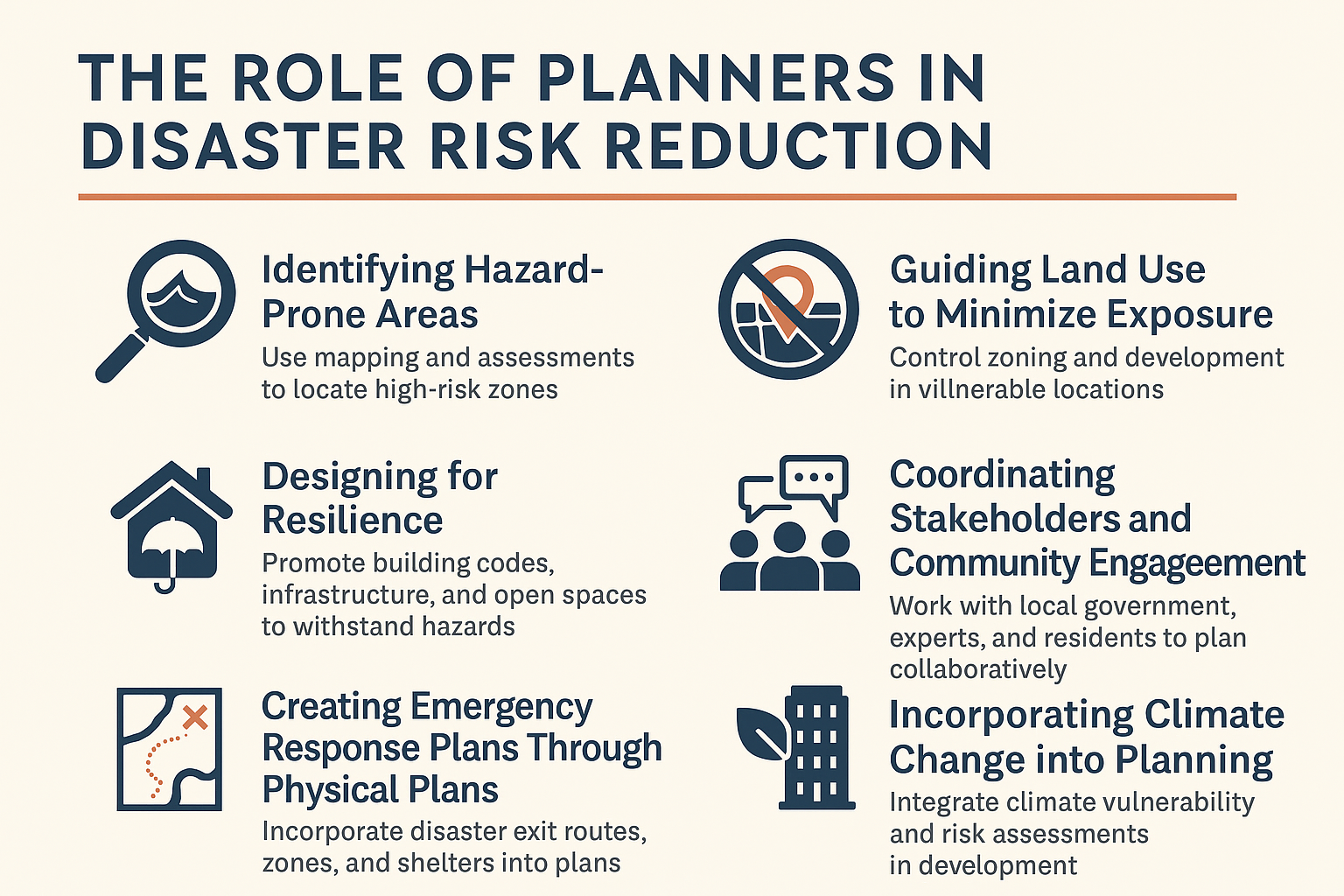
1. Identifying Hazard-Prone Areas
You can’t reduce risk if you don’t know where the danger is.
Planners use tools like GIS mapping, environmental assessments, and historical data to identify flood zones, landslide-prone slopes, earthquake fault lines, and fire-risk regions. By mapping out these danger zones, planners help inform where development should—and should not—occur.
Example in Kenya: Areas like Budalangi (frequent flooding) and parts of Elgeyo-Marakwet (landslides) require careful spatial planning to avoid settlement in high-risk zones.
2. Guiding Land Use to Minimize Exposure
Land use planning is a powerful tool in disaster prevention.
By controlling zoning and land use, planners can prevent the construction of schools, homes, or hospitals in dangerous areas. They also guide the allocation of land for critical infrastructure like drainage systems, emergency access roads, or safe open spaces.
For example, if a town is growing near a river that floods every rainy season, planners can designate buffer zones, green belts, or retention ponds instead of allowing dense construction.
3. Designing for Resilience
It’s not just about where you build, but how you build.
Planners promote building codes that require elevated structures in flood-prone areas, fire-resistant materials in dry zones, or wider roads for emergency vehicle access. Through layout plans and infrastructure designs, planners ensure that developments can withstand shocks.
Planners also push for multi-functional public spaces—like parks that can double as flood retention zones or open fields that serve as emergency assembly points.
4. Coordinating Stakeholders and Community Engagement
Disaster risk reduction isn’t done in isolation.
Planners work with engineers, environmental experts, local governments, and communities to align development with disaster preparedness. They help host public forums, share risk data, and build trust by involving residents in identifying risks and solutions.
In Kenya, this participatory approach is crucial—especially in informal settlements where official data may not capture the true on-ground situation.
5. Creating Emergency Response Plans Through Physical Plans
Plans aren’t just about the long-term—they help in emergencies too.
In Local Physical and Land Use Development Plans (LPLUDPs), planners can include emergency exit routes, disaster zones, and safe shelters. These documents guide counties and disaster response teams during real crises and ensure that growth happens in a way that supports emergency response.
6. Incorporating Climate Change into Planning
Climate change is intensifying disasters—planners must stay ahead.
From rising lake levels to unpredictable rainfall patterns, Kenya is experiencing climate-related risks that didn’t exist a few decades ago. Planners now integrate climate vulnerability assessments into regional and urban plans to ensure developments are future-proof.
Tools like Strategic Environmental Assessments (SEAs) and Environmental Impact Assessments (EIAs) help planners assess and reduce climate-related risks at the planning stage.
Conclusion: Planners as the Unsung Heroes of Prevention
While firefighters, police, and first responders are on the front lines during a disaster, planners work behind the scenes to reduce the chances of those disasters happening in the first place. Their role is preventive, proactive, and essential for long-term resilience.
As Kenya continues to urbanize and confront climate risks, it’s time we gave more attention—and resources—to planning as a frontline defense in disaster risk reduction.
Leave a Reply